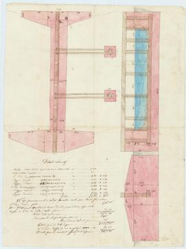
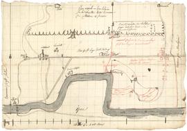
Plan pour la construction d’un barrage d’irrigation sur la Veyle par l’association des propriétaires intéressés à l’arrosage des prairies de Crottet et de Replonges, vue 01. Add to clipboard 01S019_002 Item 1845 Part of Fonds du syndicat d'irrigation des prairies de la Basse-Veyle
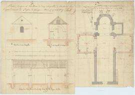
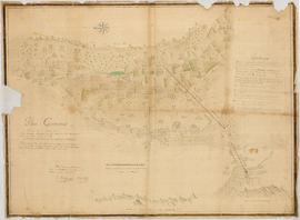
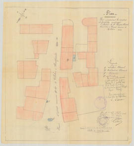
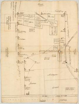
Plan pour l’agrandissement de l’église consistant en l’agrandissement de deux chapelles, vue 01. Add to clipboard 02M001_003 Item 1827 Part of Fonds communal de Grièges
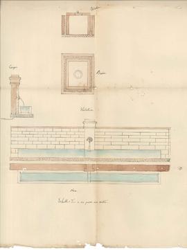
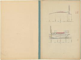
Plan pour des travaux de réparations à la fontaine de la Vérotte au hameau de Boisserolles. Add to clipboard 03N003_001 Item 1868 Part of Fonds communal de Journans
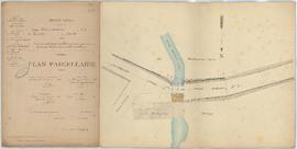
Plan parcellaire pour le projet de remplacement du tablier en bois du pont du moulin des Mollards sur la Sâne morte par un tablier en métallique sur le chemin vicinal ordinaire n°2 allant de Béroude à Courtes, vue 01. Add to clipboard 01O005_001 Item 1906 Part of Fonds communal de Saint-Nizier-le-Bouchoux
Plan issu de la procédure opposant les habitants de Tossiat au sieur Henry Zacharie Frilet, conseiller et avocat au Roi au baillage de Bresse et le sieur Juvanon, curé relative au droit de parcours dans la prairie de Bionnaz. Add to clipboard DD05_001 Item 1735 Part of Fonds communal déposé de Tossiat
Plan issu de la procédure opposant les habitants de Tossiat à Pierre Dupuys relative à la réparation du pont du Barry, au bief des Leschières, sur la grande route de Bourg à Pont-d’Ain. Add to clipboard DD06_001 Item 1619 Part of Fonds communal déposé de Tossiat
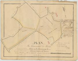
Plan indiquant le projet de réunir le hameau des Bâgés à la commune de Baneins, vue 01. Add to clipboard 00D006_001 Item [1862] Part of Fonds communal de L'Abergement-Clémenciat
Plan géométrique d'une terre de Pont-d'Ain destinée à la formation d'un champ de foire à l'échelle d'1 à 1250. Add to clipboard 01M003_001 Item [XIXe siècle] Part of Fonds communal de Pont d'Ain Le plan est signé "Perrin".
Plan géométrique des bâtiments et place de Joseph Vannet et de la place publique dite du Tilleul. Add to clipboard 04D014_002 Item 1821 Part of Fonds communal de Villebois
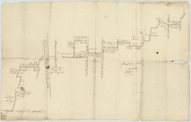
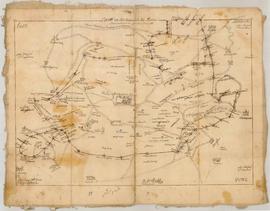
Plan géométral des chemins et territoires de Combe, Coponières, Côte du Devant et Pré de l’Âne faisant partie de la paroisse et dîmerie de Villebois. Add to clipboard 1Fi6 Item 1779 Part of Fonds communal de Villebois
Plan géométral de l’enclos de la Chartreuse de Portes suivant les limites respectivement prétendues par les Chartreux et par la communauté de Villebois. Add to clipboard 1Fi1 Item 1755 Part of Fonds communal de Villebois
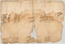
Plan figuratif des lieux contentieux entre les habitants de Bénonces et ceux de Villebois et Ordonnaz. Add to clipboard 1Fi9 Item an X (1802) Part of Fonds communal de Villebois
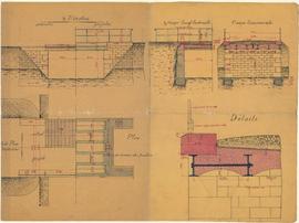
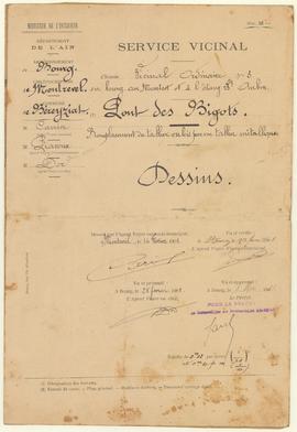
Plan et dessins pour le remplacement du tablier du pont des Bigots sur le chemin vicinal ordinaire n°3, vue 02. Add to clipboard 01O006_002 Item 1901 Part of Fonds communal de Béréziat
Plan et dessins pour le remplacement du tablier du pont des Bigots sur le chemin vicinal ordinaire n°3, vue 01. Add to clipboard 01O006_001 Item 1901 Part of Fonds communal de Béréziat
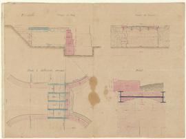
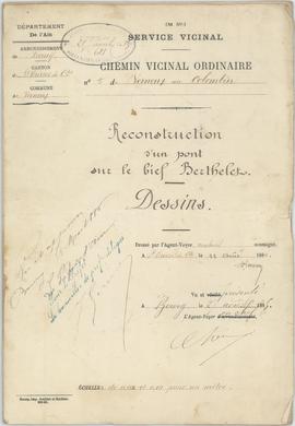
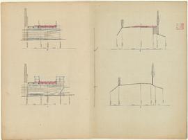
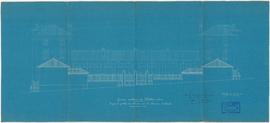
Plan et dessins pour la reconstruction du pont de Berthelet sur le chemin vicinal ordinaire n°5 de Vernoux au Colombier, vue 02. Add to clipboard 00O003_002 Item 1885 Part of Fonds communal de Vernoux
Plan et dessins pour la reconstruction du pont de Berthelet sur le chemin vicinal ordinaire n°5 de Vernoux au Colombier, vue 01. Add to clipboard 00O003_001 Item 1885 Part of Fonds communal de Vernoux
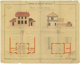
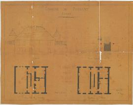
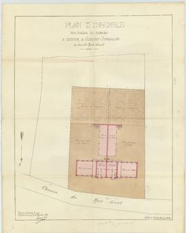
Plan en façade, coupe et élévation des deux bâtiments pour la construction des écoles mixtes des hameaux de La Galope et de Montdésert, vue 02. Add to clipboard 04M003_002 Item 1885 Part of Fonds communal de Curciat-Dongalon
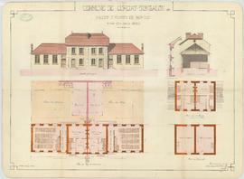
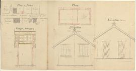
Plan en façade, coupe et élévation des deux bâtiments pour la construction des écoles mixtes des hameaux de La Galope et de Montdésert, vue 01. Add to clipboard 04M003_001 Item 1884 Part of Fonds communal de Curciat-Dongalon
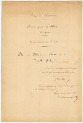
Plan du Rhône aux abords de la chapelle Saint-Léger. Add to clipboard 03O001_001_002 Item 1856 Part of Fonds communal de Villebois
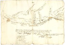
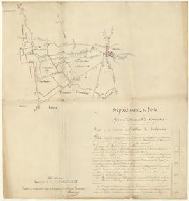
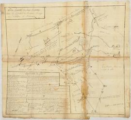
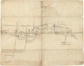
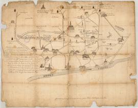
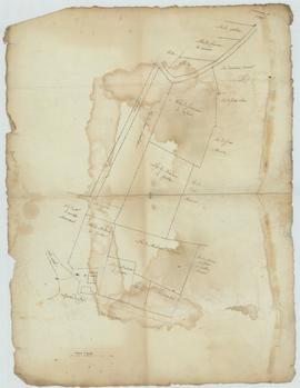
Plan du parcours de la Reyssouze, vue 01. Add to clipboard 00Fi015_001 Item [début 19ème siècle] Part of Fonds communal d'Attignat
Plan du Mas Saint-Léger faisant l’objet d’un différent entre la commune de Villebois et Serrières-de-Briord. Add to clipboard 04D010_001 Item [1820] Part of Fonds communal de Villebois
Plan du domaine de Genvais faisant l’objet d’une contestation avec M. Grumet de Montpie et ses héritiers. Add to clipboard 04D005_001 Item 1820 Part of Fonds communal de Villebois
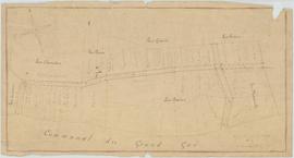
Plan du communal du Grand Gué, vue 01. Add to clipboard 01N006_001 Item 1888 Part of Fonds communal de Saint-Bénigne
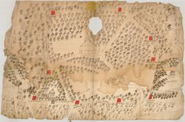
Plan du communal des Brosses situé sur les communes de Courtes, Vernoux et Saint-Trivier, vue 01. Add to clipboard 00N001_001 Item 1835 Part of Fonds communal de Courtes
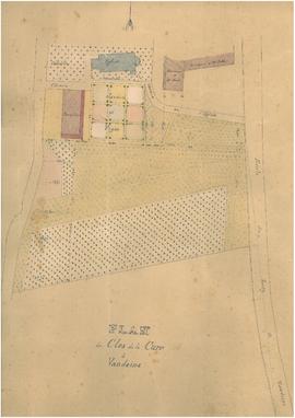
Plan du clos de la cure. Add to clipboard 01N001_001 Item vers 1819 Part of Fonds communal de Vandeins
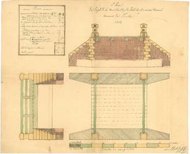
Plan des réparations à l’école des garçons, vue 01. Add to clipboard 04M001_001 Item 1888 Part of Fonds communal de Pouillat
Plan des propriétés et des maisons sur un rayon de 200 mètres de l’abattoir de Claudius Bascol, charcutier à Bouis. Add to clipboard 05I010_008 Item 1908 Part of Fonds communal de Villebois
Plan des profils en travers pour le projet de remplacement du tablier en bois du pont du moulin des Mollards sur la Sâne morte par un tablier en métallique sur le chemin vicinal ordinaire n°2 allant de Béroude à Courtes, vue 02. Add to clipboard 01O005_003 Item 1906 Part of Fonds communal de Saint-Nizier-le-Bouchoux
Plan des profils en travers pour le projet de remplacement du tablier en bois du pont du moulin des Mollards sur la Sâne morte par un tablier en métallique sur le chemin vicinal ordinaire n°2 allant de Béroude à Courtes, vue 01. Add to clipboard 01O005_002 Item 1906 Part of Fonds communal de Saint-Nizier-le-Bouchoux
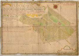
Plan des prés aboutissant sur les biefs et fossés des prairies de Chamerande et de Nizerel, vue 01. Add to clipboard 03O001_001 Item [19ème siècle] Part of Fonds communal de Saint-Bénigne
Plan des paroisses de Saint-Sorlin et Villebois. Add to clipboard 1Fi14 Item s.d. Part of Fonds communal de Villebois
Plan des ouvrages pour la construction d'un pont sur le Renon, vue 01 Add to clipboard Item 1838 Part of Fonds communal du Plantay
Plan des maisons et propriétés avoisinant l’abattoir de Claudius Bascol, charcutier à Bouis. Add to clipboard 05I010_007 Item 1908 Part of Fonds communal de Villebois
Plan des limites des mandements de Saint-Rambert et Rossillon avec celui de Saint-Sorlin qui appartenait en l’an 1115 au sire de Coligny. Add to clipboard 1Fi13 Item 1737 Part of Fonds communal de Villebois
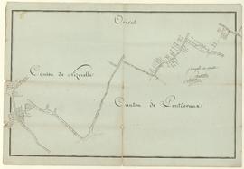
Plan des limites des cantons de Nizerel et de Pont-de-Vaux, vue 01. Add to clipboard 03D002_001 Item s.d. Part of Fonds communal de Saint-Bénigne
Plan des limites de la terre de Saint-André-de-Briord. Add to clipboard 1Fi5 Item s.d. Part of Fonds communal de Villebois
Plan des limites de la maison de Portes. Add to clipboard 1Fi3 Item s.d. Part of Fonds communal de Villebois
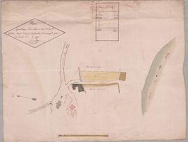
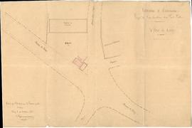
Plan des lieux pour la construction du poids public. Add to clipboard 01M002_002 Item 1886 Part of Fonds communal de Dommartin
Plan des lieux et du pavillon pour la construction d'un poids public au hameau de Bailleboeuf, vue 02. Add to clipboard 01M002_003 Item 1905 Part of Fonds communal de Chavannes-sur-Reyssouze
Plan des lieux et du pavillon pour la construction d'un poids public au hameau de Bailleboeuf, vue 01. Add to clipboard 01M002_002 Item 1905 Part of Fonds communal de Chavannes-sur-Reyssouze
Plan des grilles de clôture du groupe scolaire sur le chemin d’intérêt commun n°10. Add to clipboard 04M001_009 Item 1904 Part of Fonds communal de Villebois
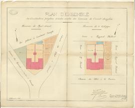
Plan d'ensemble pour la construction des écoles mixtes des hameaux de La Galope et de Montdésert, vue 01. Add to clipboard 04M003_003 Item 1884 Part of Fonds communal de Curciat-Dongalon
Plan d'ensemble de l'école de Montdésert pour la construction des écoles mixtes des hameaux de La Galope et de Montdésert, vue 01. Add to clipboard 04M003_004 Item 1885 Part of Fonds communal de Curciat-Dongalon
Plan de situation de l’abattoir Guillet au quartier du Perron. Add to clipboard 05I010_001 Item 1908 Part of Fonds communal de Villebois
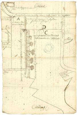
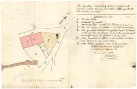
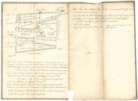
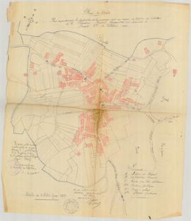
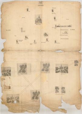
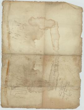
Plan de propriétés, vue 02. Add to clipboard CC002_002 Item [XVIIIème siècle] Part of Fonds communal de Grièges
Plan de propriétés, vue 01. Add to clipboard CC002_001 Item [XVIIIème siècle] Part of Fonds communal de Grièges
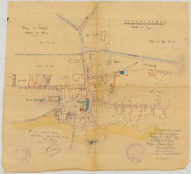
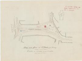
Plan de l'emplacement pour l'érection du monument aux morts, vue 01. Add to clipboard 00M003_002 Item [1919] Part of Fonds communal de Saint-Denis-lès-Bourg
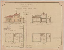
Plan de l'école de Crangeat pour des travaux d’appropriation de l’école des garçons du bourg et de l’école mixte de Crangeat, vue 01. Add to clipboard 00Fi007_003 Item 1902 Part of Fonds communal d'Attignat